By Staff Reporter
GILGIT: For a decade, this city in the shadow of the Karakoram range has been building its way into a disaster.
Satellite photographs taken in 2013 and again in 2023 show the same stretch of land along a stream on Gilgit’s outskirts, and the difference between them is stark: what was once open floodplain is now dense with rooftops, shopfronts, and roads. The stream that cuts through it is not an ordinary waterway. It is fed by glacial lakes high in the surrounding mountains, the kind capable of bursting without warning and sending a wall of water, mud, and debris down into whatever lies below.
Now, with this year’s monsoon rains arriving, Pakistan’s national space agency says that whatever lies below is a city that was never supposed to be there in the first place.
The Space and Upper Atmosphere Research Commission, known as Suparco, issued a formal warning this week that the unchecked growth of settlements along the stream has left lives, homes, and livestock exposed to a hazard the agency says was visible in satellite data for years before anyone acted on it. Construction, the agency said, continued anyway.
“The scale of potential damage has been substantially amplified by human negligence, weak enforcement of land-use regulations and the absence of risk-informed urban planning,” Suparco said in its assessment, describing a pattern the agency has now tracked across more than a decade of imagery.
A floodplain filled in, piece by piece
The geography of the threat is specific. The stream flows through what engineers call an alluvial fan — a naturally fanning, low-lying channel that widens as it descends from the mountains, built by centuries of runoff and sediment. Fans like this exist precisely because water needs somewhere to go during periods of extreme flow. They are, by design, places where a river can spread out safely rather than tearing through a single narrow channel.
Over the past 10 years, according to Suparco’s analysis, that natural flood conveyance zone has been steadily filled in with residential and commercial development, narrowing the channel’s ability to absorb a sudden surge. The agency said this kind of land-use change does more than put new structures at risk — it alters the drainage pattern of the entire watershed, pushing water toward areas that were never engineered to receive it.
If a glacial lake upstream were to fail, or if an intense burst of monsoon rain overwhelmed the narrowed channel, Suparco said the likely result would be sudden flooding over the banks, fast-moving debris flows, and destruction across a built-up area that has, in effect, erased its own safety margin.
The agency was careful to note that the hazard was not hidden. Zones prone to flooding are identifiable through the same satellite and geomorphological tools Suparco used to document the encroachment — meaning the risk could have been seen, and largely was, well before it multiplied.
Pakistan’s broader flood record underscores the stakes. The country has recorded 89 flood events over the past 25 years, according to the international disaster database EM-DAT, and Suparco said the toll from those events has been worsening as development continues to expand into active riverbeds and floodplains nationwide — a pattern the agency has separately documented as far away as Lahore, where encroachment on the Ravi River’s natural corridors has followed a similar trajectory.
The ice above is changing fast
The warning about Gilgit’s stream arrives alongside a second, related finding from Suparco: the glacial lakes that feed it, and hundreds like them across northern Pakistan, are thawing at a pace that has alarmed the agency’s monitoring team.
Suparco tracks what it classifies as “potentially dangerous glacial lakes” — bodies of water sitting behind natural dams of ice and rock debris, known as moraines, that can give way under pressure and release catastrophic floods downstream. The agency added one more lake to that watch list in the past two weeks, bringing the total to 131. The list draws on data from Khyber Pakhtunkhwa’s Provincial Disaster Management Authority, the Gilgit-Baltistan Disaster Management Authority, and the glacier monitoring center run by Pakistan’s water and power development authority, known as Wapda.
What has changed most sharply in recent weeks is not the number of lakes but their condition. In an assessment based on satellite imagery captured June 16, Suparco found that 40 of the monitored lakes were now unfrozen, up from 24 just two weeks earlier — a jump the agency attributed to accelerating seasonal melt as summer temperatures climb.
Suparco offered a measure of reassurance alongside the warning: most of those newly unfrozen lakes remain within the boundaries they have historically occupied. The real danger sign, the agency said, is a lake that expands past its previous maximum extent, which can signal that water is accumulating faster than the moraine dam can safely hold it — raising the odds that the dam gives way entirely.
For now, no lake has crossed that threshold. But given the trajectory of the melt, Suparco said all relevant authorities have been told to maintain heightened readiness, particularly in the valleys that sit downstream of the highest-risk lakes.
A ministry official calls the shift “unequivocal”
Mohammad Saleem Shaikh, spokesperson for Pakistan’s Ministry of Climate Change and Environmental Coordination, described the broader forces at work in blunt terms in an interview with Dawn, the Pakistani newspaper that first reported on Suparco’s findings.
Shaikh said the rapid warming underway across the Hindu Kush, Karakoram, and Himalaya ranges — a region climate scientists often refer to collectively as the HKH, and sometimes call the Third Pole for the sheer volume of ice it holds — is fundamentally reshaping Pakistan’s glaciers and accelerating their retreat. That, he said, is driving up the risk of glacial lake outburst floods and other hazards tied to the changing cryosphere, the layer of frozen water that blankets the region’s peaks.
Faster glacial melt initially means more water flowing into rivers that downstream communities and farms depend on, Shaikh said. But he warned that the same warming that boosts short-term water supply is also destabilizing the lakes that hold meltwater in reserve, some of which “could burst without warning, unleashing devastating floods that threatened downstream communities, public infrastructure, agricultural land and essential services,” in his words.
“The science is unequivocally clear that rising temperatures are reshaping Pakistan’s mountain ecosystems at an unprecedented pace,” Shaikh said. “Every fraction of a degree of warming increases the risk to communities living downstream. Our response must therefore be science-driven, technology-enabled and translated into timely action to protect lives, livelihoods and critical infrastructure.”
Shaikh pointed to a 2024 glacier inventory that found Pakistan is home to more than 13,000 glaciers — one of the largest concentrations found anywhere outside the polar regions, and the foundation of a water system that tens of millions of people rely on. That same abundance of ice, he said, is now the source of a growing hazard as the glaciers retreat and the lakes at their edges swell.
The ministry, he said, is working with Suparco, the National Disaster Management Authority, provincial governments, and international partners to expand satellite monitoring, refine hazard mapping, strengthen early-warning systems, and build out community-level adaptation efforts in the valleys most exposed to the risk.
Families are already living the warning
While Suparco’s report reads as a forecast, in parts of Gilgit-Baltistan the flooding it describes has already arrived.
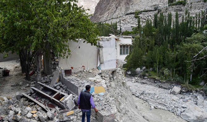
In Damas village, near the Ghizer district headquarters town of Gahkuch, a flash flood triggered by heavy rain tore through homes, shops, orchards, and farmland this week and damaged the link roads connecting the village to the surrounding area. No deaths or injuries were reported, and crews have begun repair work on the Gilgit-Shandur road, one of the region’s key routes.
The damage has been more severe in Moulaabad village, where the Ghizer River has been eating away at the riverbank for months. The erosion traces back to last year, when a glacial lake outburst flood in the nearby Talidas area blocked the river’s natural course and formed an artificial lake — one that has been steadily redirecting water toward Moulaabad ever since.
The threat receded somewhat over the winter as water levels dropped. But a recent heat wave has pushed river levels back up, intensifying the erosion. Roughly a dozen homes near the riverbank have already sustained damage, and floodwater has entered more than 30 houses, forcing families out. Crops, irrigation channels, and farmland nearby have been submerged as well, and officials say more homes remain at risk as the erosion continues to spread.
Displaced residents are now living in temporary tents, and they have called on authorities for rehabilitation support, restoration of the irrigation system, and permanent river-protection infrastructure to prevent the erosion from claiming more of the village. Ghizer Deputy Commissioner Inayatullah said the district administration is coordinating with committees representing the affected families and has been distributing tents, food, and other essential supplies, with that effort ongoing.
A separate glacial outburst in Ghizer’s Barswat Nullah swept away a suspension bridge and a section of a link road, cutting off residents in the surrounding area. A local administration team has visited the site to survey the damage, and the deputy commissioner has ordered a full assessment along with repairs to the road.
Citing the compounding risks of glacier melt, rainfall, and the possibility of further outburst floods driven by the ongoing heat, the deputy commissioner has imposed Section 144 across the district — a legal order banning swimming in rivers and streams, collecting firewood near waterways, washing clothes on riverbanks, and other activity in flood-prone areas, with violators facing legal consequences. Residents have also been urged to avoid nonessential travel and to check weather conditions before setting out on any trip that is necessary.
More alerts follow as the season deepens
Pakistan’s National Disaster Management Authority has layered additional warnings on top of the regional risk. The authority issued a landslide alert for the Baltistan Road in Skardu’s Roundu area covering July 7 through 9, and a broader alert running through July 10 cautioning that mudflows are possible along the Indus, Yasin, Ghizer, Kelek, Mintaka, and Daril rivers, as well as smaller local streams throughout the region.
Disaster agencies have been directed to remain on alert and keep up continuous monitoring as the season progresses. The public, meanwhile, has been advised to steer clear of unnecessary travel, avoid crossing rivers, and follow guidance issued by local administrations — the same basic precautions now echoed by nearly every agency tracking the region, from the climate ministry in Islamabad to the deputy commissioner’s office in Ghizer.
Taken together, the warnings paint a picture of a region caught between two forces moving in the same direction: a warming climate that is destabilizing the ice above, and a decade of development that has left more people, homes, and infrastructure sitting in the path of whatever comes down when that ice gives way.
Copyright © 2021 Independent Pakistan | All rights reserved